
General Information
| Completion: | 1915 |
|---|---|
| Status: | in use |
Project Type
| Structure: |
Arch dam Gravity dam |
|---|---|
| Function / usage: |
Hydroelectric dam / plant |
| Material: |
Concrete dam |
Location
| Location: |
Great Falls, Cascade County, Montana, USA |
|---|---|
| Impounds: |
|
| Near: |
Ryan Island Day Use Area Suspension Footbridge
|
| Coordinates: | 47° 34' 11" N 111° 7' 29" W |
Technical Information
There currently is no technical data available.
Excerpt from Wikipedia
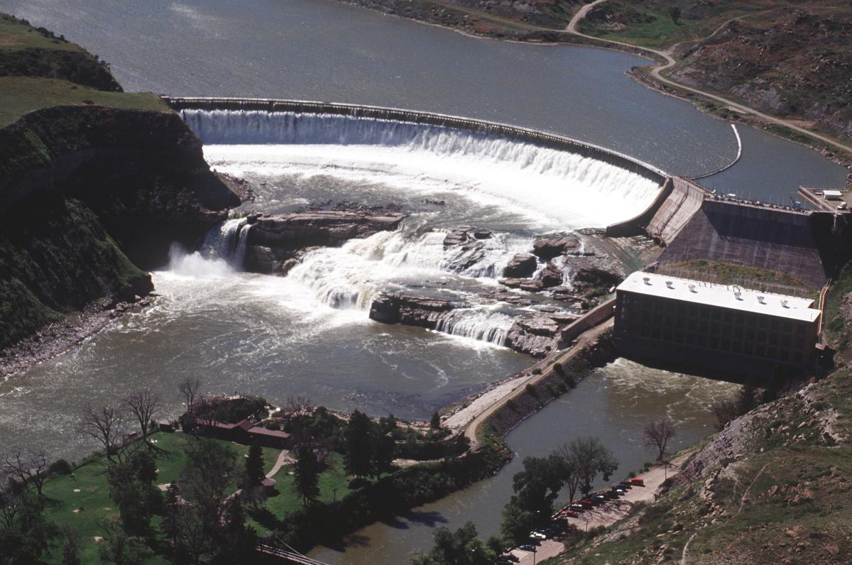
Ryan Dam is a hydroelectric dam on the Missouri River, 10 miles (16 km) downstream from the city of Great Falls in the U.S. state of Montana. The dam is 1,336 feet (407 m) long and 61 feet (19 m) high; ist reservoir is 7 miles (11 km) long and has a storage capacity of 5,000 acre feet (6,200,000 m³). It is a run-of-river dam. The dam is built on the largest of the five Great Falls of the Missouri, the "Big Falls", also sometimes called "Great Falls". Since 1915, the six-unit powerhouse on the left side of the dam has occupied a significant portion of the 87-foot (27 m) high waterfall.
The dam, built just upstream of the falls and a small island named Ryan Island, is divided into two parts. On the right side of the dam is a concrete-arch spillway structure, that when functioning, releases water over the remains of the waterfall. The center part of the dam consists of a dike that extends from the falls' base to Ryan Island (separating the tailrace from the main river, which it meets a few hundred yards downstream). It also contains a concrete gravity structure facing towards the right bank of the river and tilted to face slightly downstream. This segment of the dam contains the outlet works, a water jet that bursts out and cascades over the waterfall. The left side of the dam is a large powerhouse topped by a concrete gravity structure.
Montana Power Company originally built the dam, PPL Corporation purchased it in 1997 and sold it to NorthWestern Corporation in 2014. Since the dam's construction in the Missouri River gorge, it has flooded a fair portion of the Great Falls - the cascades between Grand Fall and Crooked Falls, which lies several miles upstream - and reduced the flow over Great Falls to such an extent that much of the bedrock is visible. The dam was constructed on top of a 10-foot (3.0 m) cascade that Lewis and Clark observed to lie just upstream of Grand Fall. Upstream of Ryan Dam the next dam is Cochrane Dam, then Rainbow Dam, and the uppermost is Black Eagle Dam. Downstream of Ryan Dam the next dam is Morony Dam.
Text imported from Wikipedia article "Ryan Dam"
and modified on 23 July 2019 under the CC-BY-SA 3.0 license.
Participants
Currently there is no information available about persons or companies having participated in this project.
Relevant Web Sites

- About this
data sheet - Structure-ID
20030445 - Published on:
22/08/2007 - Last updated on:
01/06/2023
Structurae cooperates with


