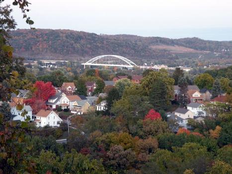
General Information
Project Type
| Structure: |
Tied-arch bridge |
|---|---|
| Function / usage: |
Motorway bridge / freeway bridge |
| Material: |
Steel bridge Structurae Plus/Pro - Subscribe Now! |
Location
| Location: |
Coraopolis, Allegheny County, Pennsylvania, USA Glenfield, Allegheny County, Pennsylvania, USA |
|---|---|
| Crosses: |
|
| Carries: |
|
| Part of: | |
| Coordinates: | 40° 30' 55.54" N 80° 8' 2.47" W |
Technical Information
Dimensions
| main span | 221.0 m |
Materials
| deck |
steel
|
|---|---|
| piers |
reinforced concrete
|
| arches |
steel
|
Excerpt from Wikipedia
The Neville Island Bridge is a tied arch bridge which carries Interstate 79 and the Yellow Belt across the Ohio River and over Neville Island, west of Pittsburgh, Pennsylvania.
Construction
Opening in 1976, after five years of construction, the Neville Island Bridge was the last link to finish on the 180 mile long I-79. It is also the second longest single spanning bridge in Allegheny County. The engineers who built it were the Pennsylvania Department of Transportation (PennDot), making it with a 125' arch.
Problems
In 1977, a crack was discovered in the bridge. The bridge was immediately closed to traffic and remained closed until repairs could be performed. It was determined that the crack was not due to poor bridge design, but due to a failed weld.
Improvements
During 2010 PennDot completed a $20.8 million improvement of I-79, Neville Island Bridge as well as other intersections.
Text imported from Wikipedia article "Neville Island Bridge"
and modified on 23 July 2019 under the CC-BY-SA 3.0 license.
Participants
Relevant Web Sites
- About this
data sheet - Structure-ID
20006125 - Published on:
11/10/2002 - Last updated on:
05/02/2016


